Africageodownloads.info
Land Rights in a Spatial Environment
1Powertech IST Data, Pretoria, South Africa,
[email protected]
Abstract
In the present day and age, land is scarce and infrastructure expansion is a growing concern. This
concern affects any business that needs to either register servitudes for land or manage statutory
land regulations. Business Intelligence related to land and right management is essential to
maintain, track and enable planning of infrastructure. A system which can capture and visualise
these needs electronically, will solve these growing pains.
LARIS is a spatially enabled Decision Support System, which has operational, financial and
strategic benefits to serve the whole organisation. Organisational challenges which have lead to the
current LARIS include:
1. The need for a visual representation of existing and vacant rights allowing for a global view 2. GIS capabilities that support visualisation of a right 3. Management of the right lifecycle stages, such as Planning, Acquisition, Registration,
Maintenance and Cancellation.
4. Different types of information and business rules applicable in the various stages
Spatial visualisation is an essential part of land and right management, as it enables strategic decisions, helps identify risk and supports financial cost estimation processes. For example, when a route for utility infrastructure is being planned, alternative routes can also be placed for comparison to provide users with a visual representation route aspect across various lands for the alternative options. Further spatial visualisation is possible in 3-Dimensional views by exporting data files to Google Earth. Critical rendering includes the cadastral information because it is the platform of various automated functions for data retrieval during the various lifecycle stages of a right. This data includes that of properties, farms; holdings and land owners. The current implementation integrates with Windeed to retrieve land owner and company information from the Deeds Office/CIPRO and stores it in LARIS with other rights information. LARIS can integrate with a Document Management System, to link legal and descriptive documentation to a right within the system. The ability to relate and link documents (legal or informative) directly with a visual object allows the user to automatically retrieve a list of available documents when selecting a right spatially and viewing these through the selection of a URL.
The open architecture within LARIS will allow integration to other systems if needed.
Here we are, in the 21st century, and we struggle with the availability of land. The situation is getting worse; more land is needed for significant reasons, and it is impossible to comply with everyone's needs. Consider big companies such as utilities that want to build a large structure on land. Can they do this in no man's land? No, it must be on land that belongs to someone, which often leads to incessant negotiations at times. Utility companies need space to meet basic needs for the population in Southern Africa. However free land is scarce and expansion is increasingly complex. This theory determines that the dilemma will amplify as it starts all over. Throughout the white paper a division of Eskom Pty Ltd will be used as an example. Amplified dilemmas require a holistic solution, such as the land and rights solution, LARIS. The author will guide the reader by first describing the dilemma and business concerns, after which these will be addressed by the key principles of LARIS. Once this is done, the top class product is revealed, looking at product platform features, the internal product feel and the Google teaser which then leads to the future possibilities and conclusion of the paper.
The Land Right Management Dilemma
A holistic definition for Land Management is best described by the UN Conference on
Environment and Development;
The broad objective to facilitate allocation of land to the uses that
provide the greatest sustainable benefits and to promote the transition to a sustainable and
integrated management of land resources.
Stimulated development within an enterprise such as Eskom, encompasses numerous overpowering business processes in which legislation should be considered before enquiring about property. These business processes that require management and compliance include: manage assets; vacant servitude maintenance; procurement; 3rd party applications etc. The business concerns and need described below are relevant to most facets in any of the mentioned practices. The process of Rights management is not that of a once-off transaction, but rather a tedious process to completion and the issue of tracking information during this process is severe. With the land scarcity the whole process seems just to stretch out, and most of the asset information value becomes benign. Such growths with the current lack of mechanisms required to plan and control these expansions results in a loss of the holistic business view as well as the feel of a well defined process. Conventional land management mechanisms have frequently been viewed as a failure due to it not satisfying the objectives of the land user resulting from a lack in grouping and associations of all the valuable information needed to create a valid spatial land right. The following example part takes the Eskom environment where LARIS does not yet exist. Where an association needs to be made to land or property, a map must be referenced, and documents should be drawn from cabinets. At this point it is frequently discovered that the documents were misfiled and part of the process must be repeated unnecessarily, therefore leading to the next concern. There is limitation to the accessibility of information regarding land right acquisition resulting in the holistic approach once again being set aside.
With the non-holistic approach issue, it is impossible to decide effectively which part of land can be re-used from existing servitudes. Empty property, that no longer has infrastructure on it, is deemed vacant. Such property must be identified since the unused property still belongs to the specific industry, yet tracking re-use of existing servitudes stays impossible or uncertain because of the absence of spatially related queries and views to support the process of effective decision making. This results in persistent unwanted cost. The following section describes the principles of LARIS that will meet and mitigate these concerns.
Key Venture Principles
Given the mentioned dilemmas, a need has been established for a mechanism to be implemented in the Land Management process to assist with decision support regarding Planning of Rights. This involves getting the Right and all valuable information to an optimised space where only maintenance is needed on the Land Right.
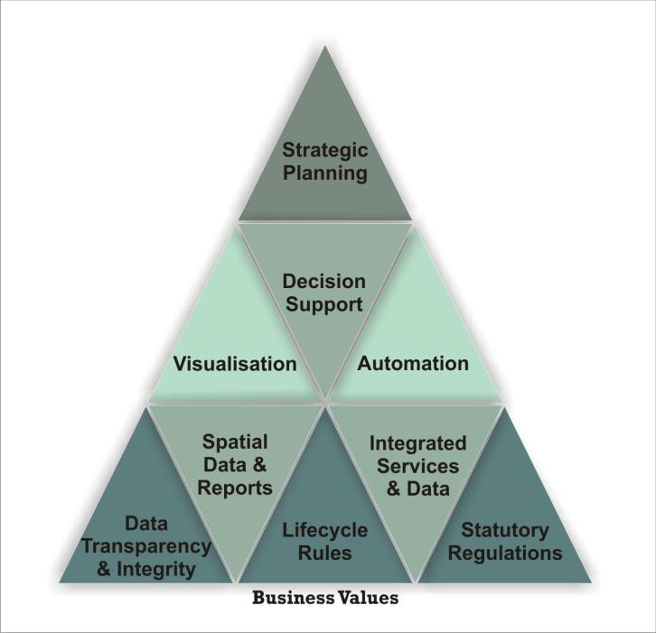
The Key Venture Principles group the Critical Success factors needed to satisfy a holistic Right
Management solution. These are summarised in Figure 1 and further described in the paragraphs
that follow from pinnacle to foundation. Each of these business values interact with one another
and overlap with one another to create business solutions and benefits.
Figure 1. Solid Solution Principles
Strategic Principles
Strategic planning is a mechanism that plays an important role in the custodianship of asset
information as an input to support the planning processes at various levels. Such a platform is
required, to allow alternative plan creation and comparison for strategic decision making.
Accurate information received and captured from the field personnel enables the identification of
risk and alternatives for contingencies identified by middle to senior management.
To achieve a high level of integrated processing in Land Management, the procedure must make use of the following:
1. Sustainable Policies and documentation which will be used in the management of land. 2. On-going strengthening and improvement of the planning management process as well
as the monitoring and evaluation of all historical information tasked.
3. Creation of mechanisms to support the needs and objectives of role players in the
business processes.
4. A holistic approach to manage land and land-use, keeping the big picture in the forefront
for all business intelligence purposes.
5. Integrated activities and inputs combine inputs of the Land Management discipline,
where required in necessary value chains.
6. As a mechanism which can be used throughout the Enterprise and affiliated entities, it
enables information sharing on a standard platform.
Projected Principles
A principle level which caters for deliberate savings considers business concerns such as
automation of repetitive work. Such reflection enables shorter turn-around on the end to end Land
and Right Acquisition process, resulting in savings of value, time and money for the utility.
With the added benefit of greater visibility of Projects and Right status information, a better process can be followed for decision making; timely interventions and escalations to expedite progress and prevent unnecessary delays can be done.
Operational Principles
With extensive land use, it is important to have effective control over the lifecycle of a right. The
effective management of the phases of a Right will ensure that the information related to a right is
accurate and can support Reporting which is needed for risk management.
Version managed and is spatially enabled data allows geographic reports and views for Land and
Right Information. The seamless integration to other data sources ensures a user friendly system
with added advantages of information available at the user's fingertips.
LARIS - New Class of Product
A Land Asset Management product is essential. The focus should not only be on Spatial Planning,
but should have a holistic approach. Working together with Eskom Distribution, Powertech IST
has designed and developed a product according to a holistic approach. It is called LARIS (Land
and Rights Information System).
LARIS is the Enterprise standard for managing a property portfolio within a utility industry.
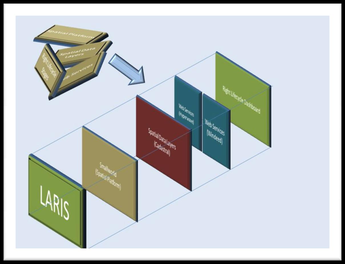
Figure 2. LARIS Components
The design of the product focused on the user and the ease of use required to capture information, and also to track land rights. The capability to bulk upload historical (existing) information ensures that most value add due to the extent. The Right Lifecycle, which was the main focus and driver of the functionality needed, ensures an embedded business process alignment in both Right Lifecycle Management, which is the process and in LARIS, which is the process-driven application.
Product Platform Features
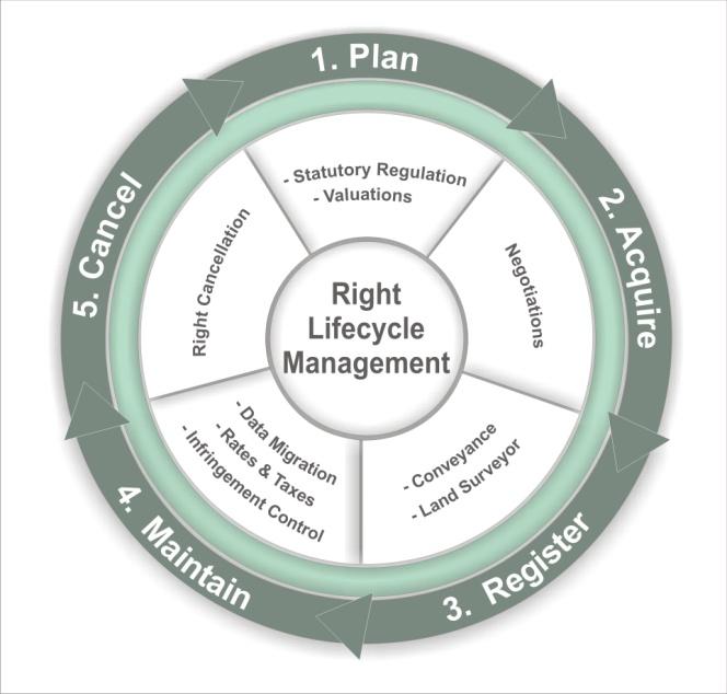
The diagram below depicts a typical Right lifecycle. Any Right will move through these phases; Plan, Acquire, Register, Maintain and Cancel. Contained in each of these stages are various user and business cases that require spatial platforms, integration, auditing and spatial information layers.
Figure 3. Right Lifecycle Management Process
A Spatial Platform. Without visual presentation a clear picture cannot be formed. With a
proper spatial system additional spatial queries and planning can be done. General Electric
(GE) Smallworld Core Spatial Technology (CST) is the technology used to create the spatial
platform for LARIS. This platform does proper version management which requires that
every LARIS user has his/her own workspace, and when this data is ready for a production
environment the system will synchronise the user and parent workspace data so that it is
available for all the users.
Integration is at the core of the holistic information management approach that keeps
information associated without any duplication. Integration within LARIS is based on a
service-orientated architecture (SOA) approach; this is a service orientated business
technology which uses Web Services. There are two core integration components:
Windeed™ is the source for all the information captured by the deeds offices. The
purpose is to query the information source (in bulk) for Land Owner Information, retrieve it and store it within LARIS. There is a cost implication when querying Windeed™, therefore when the information is stored within LARIS, reduction of operational cost is evident.
Document Management System (DMS) is the repository for all stored documentation
related to a spatial element created in LARIS. The functionality exists to call documents associated with a land object. Eskom has selected Hyperwave as their enterprise solution.
Auditing. With every change or addition of a new record, an Audit Trail is written and
history reports can be generated for auditing the system within which LARIS operates.
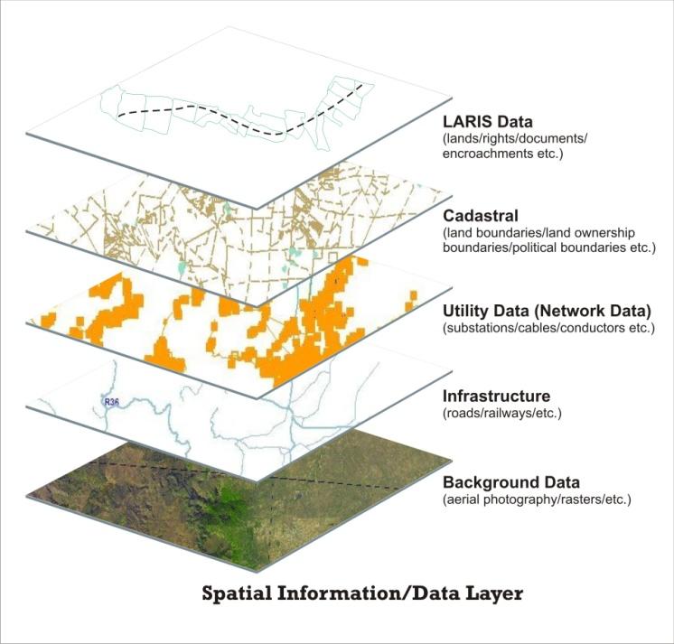
The Spatial platform makes provision for other Spatial Data Layers that serve as reference
information. There are mandatory as well as optional datasets. The mandatory dataset required for LARIS is Cadastral data. Optional datasets include, but are not limited to; Utility, Infrastructure (e.g. Transit) and Background Data (Raster or SPOT5).
o Spatial data layers are implemented with various degrees of importance and display
value in LARIS. Figure 4 depicts this in more detail.
Figure 4. Spatial Data Layers
All of these product platform features are supported by interfaces that can guide a user who may not be as acquainted with the various processes as they possibly should be. The following section describes how this is achieved.
User Interface Functionality
It has been established in the product platform features that all Rights move through various stages.
Figure 5 represents these characteristics as part of the system interface that is presented to the user.
Figure 5. Right Lifecycle Dashboard
To manage property portfolios in an industry, a structured management tool such as LARIS is needed so that planning, decision support, optimisation, tracking and control can be done effectively.
The Right Lifecycle Dashboard (Figure 5 above) is an interface which guides the LARIS
user through the stages of a land right. It consists of a step-by-step process for land management, depending on which part of the Right Lifecycle the business process corresponds to at a given point.
Automated Status changes are achieved through the forced right states which are
dependent on key data entries, these may be a date or not. Forced state changes enable spatial differentiation based on mandatory fields and are configurable. Eskom has implemented the stages shown in as their five statuses.
Automated Schedules and agreements are relevant to spatial and no spatial documents.
Templates enable automated schedule generation and bulk legal agreements generation for a project.
Reporting: Pre-defined reports are generated. These write to Microsoft Excel. Figure 6
defines a list of the reports in LARIS.
Figure 6. Report List of LARIS
Apart from this functionality, there are various other possibilities for displaying information that has been mastered in LARIS. This includes the existing write-out to Google Earth.
Exporting to standard systems
Export to Google Earth (KML) – This is a function which will export the data stored in the
database and display it in Google Earth when prompted to do so. The benefits of such an ability
includes:
Utility expansion planners are able to determine more spatial information prior to a field
analysis being done.
Enabled communication due to the visual references between negotiator and land owner.
Creating awareness across an enterprise, building the business intelligence on a platform
that is well understood by most employees already.
Displaying enterprise data on a 3 dimensional platform.
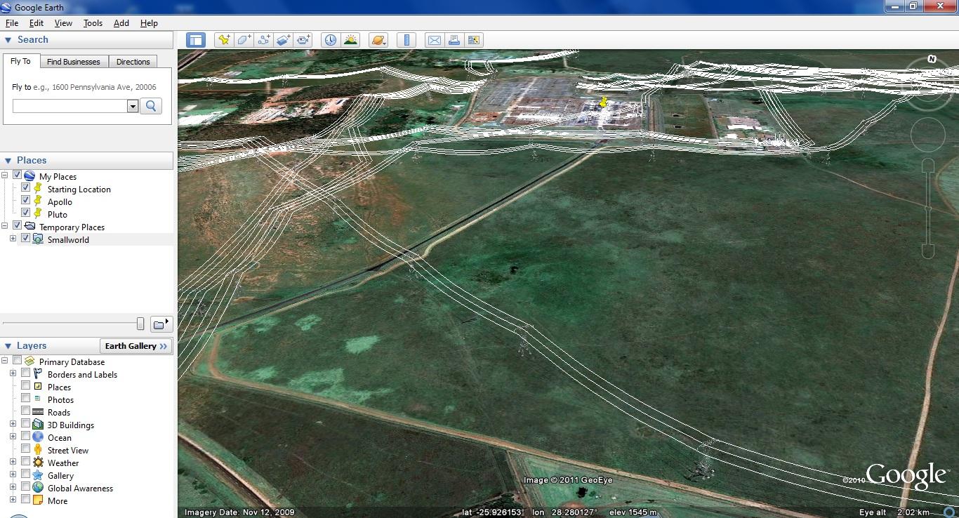
Figure 7. 3-Dimensional View for structures of Eskom (within Google Earth)
Just as the Right information can be displayed in Google Earth, so can the infrastructure if it is captured on the same platform as that of the Right. shows how an extract of such an exported file may display in Google Earth in a selected 3 dimensional view.
LARIS has a 2 dimensional view which is represented in . The viewing and common referencing of a 2- dimensional model has little comparison to the powerful 3 dimensional model view.
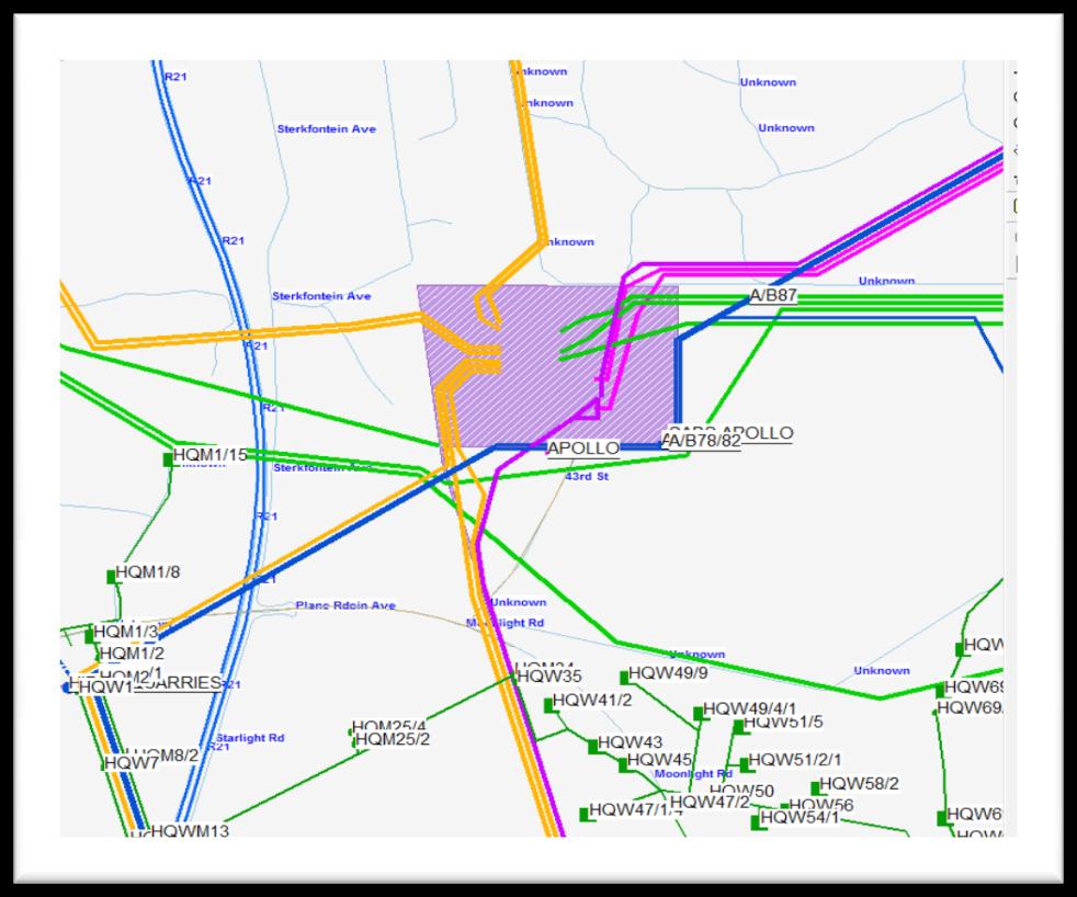
Figure 8. 2 Dimensional View for structures of Eskom (within LARIS)
Each function has its purpose; each system has its area of responsibility and accountability. Each utility has interacting purposes, responsibilities and accountabilities that are contained in a value system which is best driven through effective (process-driven) systems, rather than efficient (saving time) systems. LARIS is an effective holistic enterprise solution.
References
White Paper on Spatial Planning and Land Use Management, Ministry of Agriculture and Land Affairs, July 2001,
Source: http://africageodownloads.info/026_piani.pdf
Therapeutic Hypothermia Annmarie Keck RN, CEN, EMT-B Clinical Outreach Educator History of Hypothermia Baron Dominique Jean Larrey, a surgeon in the Napoleonic army who invented the "flying ambulance" to rapidly rescue wounded soldiers from the field, described that during the Napoleonic wars wounded soldiers who were put close to a campfire died earlier than those who were not re-warmed.
Research Children's Health Decrease in Anogenital Distance among Male Infants with Prenatal Phthalate Exposure Shanna H. Swan,1 Katharina M. Main,2 Fan Liu,3 Sara L. Stewart,3 Robin L. Kruse,3 Antonia M. Calafat,4Catherine S. Mao,5 J. Bruce Redmon,6 Christine L. Ternand,7 Shannon Sullivan,8 J. Lynn Teague,9 and the Study for Future Families Research Team*